Sunday 23 February 2020

Trip Report: South West Coast Path - Section 1 - 16-20 July, 2017

Shortly after deciding I wanted to thru-hike the PCT, I realised I would need to up my backpacking skills, so I planned a trip for my partner and I along the beautiful 600 mile South West Coast Path in England. This was my first multi-night backpacking trip and my partner's first backpacking trip full stop. We had only slept in our tent once before setting out for 5 days of walking and camping along the Somerset and North Devon coast.

Distance: 118 km
Ascent: 7,535 m
Max elevation: 316 m

Day 1 - Minehead to Porlock (20 km)


After walking along the sandy beach at Minehead the night before we started, we stayed in a B&B overnight and had a nice cooked breakfast before setting off early, stopping for photos at the sculpture that marks the beginning of the path.

At the monument in Minehead, about to set off on my first backpacking trip as an adult, with lots to learn and lots to see.
Coming out of Minehead, the trail climbs almost immediately up a steep, wooded bank as a sign of things to come. The weight of our bags was a little bit alarming at first and it took me a little while to figure out how to use my trekking poles to help with the hills, but eventually got the hang of it, and especially appreciated having them on descents.

Exploring medieval ruins that have nearly been swallowed up by the forest.

A detour brought us to the ruins of a small medieval chapel that was now engulfed in a sea of nettles. I wandered around it, snapping a few photos, and working on strengthening my immunity to nettle stings. We had another steep climb through the trees to rejoin the main trail and I was already wondering what I'd let myself in for. My massive bag made every uphill step feel like a weighted squat and I was shattered by the top. Shortly after, there was another detour labelled "Rugged coastal path" that seemed to descend rapidly before climbing back up the hill we'd just done. I had been planning to take it, but the first climb made me vacillate. In retrospect I wish we had taken that path, simply because I have a better understanding now of my own endurance levels and I know we could have done it, but this was the first day of my first backpacking trip and I lacked the confidence that I could deal with the extra climb.

A doggo at the crossroads. We took the high road to avoid an extra decent to sea level and back up again.

Instead, we took the inland path, looking out over the rolling, green hills of Exmoor, but it quickly clouded over. The view cleared slightly on top of a beacon hill with a trig point on top, but it remained misty for the rest of the inland route. We wandered around the earthworks of an iron age hill fort, then encountered a slightly lost backpacker who was sitting on the path looking slightly defeated. She was petite and was wearing a large men's backpack that fit her very badly, clearly struggling under the weight of it. She told us that she was intending to do as much of the trail as she could over 6 weeks as she tried to keep her shoulder straps from sliding off. We pointed out where the trail went, descending into the fog, then carried on.


We didn't know it yet, but this is typical of the South West Coast Path - steep sided valleys with a beach or a bay where we could camp and/or get some food before heading up another big climb.

A long, steep descent had me singing the praises of my trekking poles for saving my knees, and finally we saw the sea again, walked out to a ruined coast guard hut, had our photo taken, and walked along the shingle beach for a bit. We found a small tea room in a thatched roof cottage and had a lunch of scones with jam and cream, despite not being in Devon yet. After we finished our very healthy lunch, we headed out across a boardwalk that kept us from slogging through a marsh, and then to our first campsite in Porlock. We had a view of the sea, and of the south coast of Wales, and we pitched our tent next to the overwhelmed backpacker. She had found an outdoor outfitter and was going to take a rest day to get fitted for a new bag - I must admit I was relieved to hear it! Our dinner was a mug each of soup from a packet and a sandwich purchased from the local shop, and we turned in for the night.

Our home for the night.


Day 2 - Porlock to Lynton (30 km)


First thing in the morning I did some yoga to stretch out my calves, we made some tea using the kettle at the campsite rather than our stove and drank smoothies we'd bought at the convenience store for breakfast. We hit the trail, passing a very cool little post-war chapel made of corrugated tin sheeting, a partially submerged petrified forest and some strange arches and walls that wound through the woods and looked like something from The Prisoner or a Miyazaki film.


St. Nicholas Church, made of reclaimed tin sheeting, and with this gorgeous little sign.

Most of the morning was spent in the woods, and as the sun streamed through the thick green canopy and the air was warm and quiet, I felt like Rip Van Winkle, or someone who was about to be abducted by faeries from some sleepy little glen. A sign pointing off the trail toward Ash Farm seemed to compound this feeling, as did the tiny hamlet of Culbone, nestled over a waterfall in a lush little valley.
I'm seldom happier than when I'm walking in the woods.
We stopped at Culbone Church, a medieval church mentioned in the Doomsday Book and the smallest parish church in England. We sat in the sunny church yard where the robins were practically tame and the sound of burbling water under the oak and walnut trees cast a sleepy spell over the place. After resting our legs and eating a bit of food (probably what the robins were really interested in), we decided it was best to move on from Culbone, lest we stay forever.

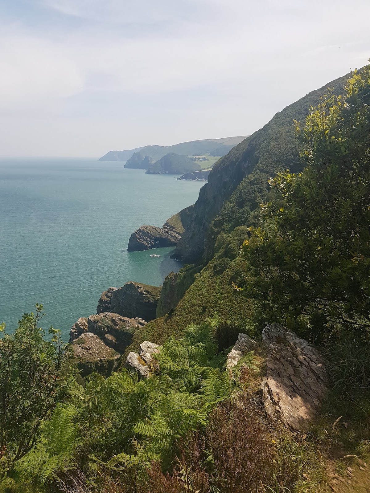
We were constantly on a roller coaster, up and down hills, and the forest soon opened up into more pines with less undergrowth. We passed a couple of veterans who were raising money for veterans with PTSD by walking the path. Once we got out of earshot I started singing "In the Pines" - the Nirvana version, of course - because it seemed fitting. The scenery changed again as we entered a forest of invasive rhododendrons that densely covered the steep-sided hill and blocked our view of the sea to our right, but once they dropped away we were left with a jaw-dropping view from our steep path that occasionally turned to scree. To be fair to the South West Coast Path, we were on another detour out to a lighthouse when it got truly steep, so the real path doesn't try quite so hard to murder you.

Crossing a scree field above a steep plummet to the sea with a heavy bag on your back? No big deal.

By this point we had a "f*ck it" attitude and were taking any detours we came across. We did an extra climb up Butter Hill, the highest point in the area, with a great view over the fields and pastures below, as the woodland had dropped away. After coming down Butter Hill, we stopped at a pub to rest our legs and to have an early dinner, sitting outside on the picnic benches next to a narrow but busy country road. It had already been a big day and we had another 7 km to do before we got to our campsite. I wanted a fizzy drink but not soda, and my partner suggested lime and soda, which I'd never had before. It went down amazingly well. For those not in the know, most pubs in the UK have lime and soda as an option for designated drivers. It's just lime cordial with soda water, and it has become my official post- or during-hike drink. It's just sugary enough to be really nice after exertion without being quite as sickly as a normal flavoured soda and it's a nice break from plain water.

No matter how many more miles you have to do, it's always a good idea to soak your feet in cool water on a hot day!

When we set off again, we quickly headed back into a wood of mostly oak and soaked our feet in a valley at Watersmeet, where two streams merged into one and were crossed by an old stone bridge. I was pretty tired by this point and was eager to get to our campsite. But we still had some climbing to do, and this was up a hill that seemed to be a massive colony of flying ants. The bugs were thick, the air was humid, and the views were scarce. Where we did catch glimpses of the dramatic hillside on which Lynton stood, it was too buggy to stop and enjoy them. I was practically racing down the hill on the other side as the sun was getting low on the horizon and I was out of water. We got down to our campsite after 8, pitched our tent in the deepening darkness, and showered before bed. We gave each other leg massages and slept the sleep of those who have walked 50 km in two days.

Not my favourite section of trail - buggy, hot, humid and at the end of a very long day. The view here looks better than I remember, thanks to my crabby mood!

Day 3 - Lynton to Watermouth Valley (28 km)


We awoke to find our devices had no power and the campsite didn't have anywhere to charge them for free. We had a fry up at the cafe while we kept jumping up to feed the chargers with change and tried to get some juice via the solar panel my partner was carrying. It was a very late start by the time we set off. Despite the mileage the previous day I felt pretty good and by this point we were pretty quick at breaking camp. But we were put to shame by a fellow hiker who we had been camping near for the past two nights. He had a one-person tent that was so small and cramped looking that we called him "Sarcophagus Pete", and he was normally up and hiking before we'd finished our tea in the morning.

Lynton, built on a hillside so steep that they have a funicular railway.

Goats!


The Valley of the Rocks

We had camped a little bit outside of Lynton and couldn't afford to stop and look around the town as we walked through, but it looked adorable. The hike out of town was one of my favourite stretches - first through a herd of goats nibbling grass on the cliff sides, then into the Valley of the Rocks, a pretty spectacular field of boulders and crags that would have looked at home in Middle Earth. The path started as a thin ribbon on the edge of the wild, open sea cliffs, then wound inland, past day hikers and dog walkers.

This section of the South West Coast Path is constantly varied between rocky coves, wooded valleys and hilltop views.
We passed a huge abbey and its sprawling grounds, then into more woodland. All of this was in glorious, bright sun, and we were beginning to get great views of the headlands that both lay ahead of and behind us. It's a wonderful path for being able to mark your progress visually, and as we ticked off more headlands we had some significant drops and climbs, one right after the other, pausing for a foot bath in a stream, and for some tuna wraps by the side of the trail. The day started pretty warm and not for the first or the last time we regretted not having time to be able to find our way down to the turquoise water below for a proper swim. 

Headland after headland on the North Devon coast.

I saw, and nearly stepped on, two adders, but sadly didn't get any photos of them before they slithered off. As we traversed the steep, wooded hillsides of a National Trust area, I saw two red deer charging off into the trees and was so transfixed that I stepped off the trail and fell hard on my hands and knees, luckily, rather than falling down the hill. Getting to my feet with around 25 lbs on my back was pretty hard! 

Grateful for outdoor pub seating, lime and soda, and a view.

We hit a high point just as rain started to fall, and headed into Coombe Martin with our pack covers on. The path was narrow and wound between thick bushes, and a herd of sheep we'd encountered at the top of the hill ended up running away from us down the trail, basically all the way into Coombe Martin. We decided to stop at a pub right on the beach for a greasy dinner and a drink, once again opting to eat early and then do a few more kilometres to our campsite rather than having to carry our dinners with us. It's a definite benefit of hiking in the UK, as more often than not you can have a good hot meal from a pub or cafe every day if you want. We also chatted to some of the patrons about what we were doing and their impressed comments made us feel proud and happy of what we'd accomplished so far.


Enjoying sunset over the sea.

As we were making our way to the campsite I'd booked, the sun was getting low and beautiful sunset colours were transforming the sea and sky, and we spotted below us a campsite overlooking the water. We turned aside and opted to stay there instead, pitching our tent as the sun started to go down. The sky faded from tropical oranges and pinks to a deep navy blue, and over the horizon behind us a single cloud began to mount up, a sign of things to come. That night a storm of wind and lightning woke me up and had me feeling a little bit nervous, especially when I could feel the wind lifting the floor of our tent, but our tent did fine.

A clear night, with one very ominous cloud on the horizon.

Day 4 - Watermouth Valley to Woolacombe (24 km)

In the morning we woke up and made some baked beans on the stove, and as we sat there cooking, Sarcophagus Pete strolled past on what we had taken as merely the main access road for the campsite, but turned out to be the actual South West Coast Path. We had camped about 2 metres from it, rather than 2 km away at the campsite I had originally booked.

The rain overnight had soaked the socks and things we'd hung out to dry, so we stayed long enough to dry them a bit more, and set off into what was an overcast and slightly blustery morning. The first part of the day was pretty unassuming, winding alongside busy roads, ducking between back fences of terraced houses, and staying relatively flat through thick bracken overlooked by expensive houses. We ran into Sarcophagus Pete waiting for a bus on the outskirts of Ilfracombe - he'd left his trekking poles in a cafe and walked across town before realising. The bus skirted a huge hill that overlooked Ilfracombe harbour, but the trail went zig-zagging up it instead. It was heavily wooded, so there were only a few viewpoints, but we got a nice view of the strikingly incongruous Damien Hirst statue, Verity, striding above the harbour. 

Verity, Ilfracombe
Back down into town on the harbour I posed for a photo with Verity and we wandered around a bit looking for somewhere to have lunch, hiker hunger having hit us fully by this point. After some searching, my partner identified a little tea room where we sat outside next to an artificial waterfall and ate our body weight in food. I had an omelette and a mandarin orange sponge cake the size of an airplane wheel chock (that I still day dream about), and my partner had an afternoon tea for two on a tiered porcelain cake tower. It was definitely too fancy for us. We bought and wrote postcards and while I was waiting for my partner to find stamps to send them, I witnessed a dog lash out and bit a man's hand as he walked passed. They were right next to me and I'd been looking right at them - the man hadn't even looked at the dog. I was able to help with my meagre first aid supplies as the dog's owner kept insisting, "She's really gentle! My daughter is disabled!" The man's hand was bleeding badly from a deep gouge wound and his friend was urging him to go to hospital. I felt bad for everyone involved.

"This is my life now." Nothing but ups and downs.
After all of that, we left Ilfracombe after 2 with most of the day's hike still to do. Despite overcast skies it was still hot and humid, and I ran low on water again. First, there was a big climb up a winding hill, with benches every few metres, it seemed. We had already invented the "South West Coast Path Bench Density Scale" as a measure of how close to a town we were, and this section was off the chart. Quickly, though, we were on remote moorland, with the clouds spitting down on us and a deafening wind in our ears. We leapfrogged with a fit-looking couple clad in bright GoreTex (I named them "The Fogles", after adventurous TV presenter Ben Fogle), but otherwise we were alone on steep and desolate moors. I sang to keep my spirits up, and my partner noticed that I tended to do this more when I got dehydrated. We also spotted a VERY lost looking car driving off-road to the top of one of the hills out in the middle of nowhere and turning around, presumably another victim of blind faith in Sat Nav.

After enough time on trail, things get a little bit weird.

The first civilisation we reached was a group of houses on a steep hill. One guy (who looked like Faramir from Lord of the Rings) was out working in his garden and we stopped and chatted for a bit, then descended into Lee Mouth, an adorable little village on a cove, where people were sitting out enjoying drinks looking over the sea despite the grey weather. We dropped down to a number of beautiful coves, only to climb back up again until up and down stopped feeling significant. The guide book described this trail as a roller coaster, but I'm pretty sure even roller coasters have more flat sections. This was the first time I had to ask my partner if we could sit down because I wasn't sure if my legs would keep going. We found a bench, a sure sign that we weren't too far from civilisation, and took a little rest as the wind and rain picked up. Then we rounded the wild and alien-looking Morte Point and headed along the wall of a wide bay with a long, sandy beach: Woolacombe.

Lee Mouth, Devon. Very cute.

When we reached the paved streets of the town, we were doing a zombie-like walk that to most hikers is known as the "hiker hobble", but that will forever be known to us as "the Woolacombe Shuffle". We grunted at each other to confirm that we would go to the first restaurant we encountered, a burger joint with an outdoor deck so that we wouldn't offend other patrons with our smell and our big bags, and ate a big dinner.

Unbeknown to me, the "campsite" I'd booked was a hellscape made real, AKA a holiday park. I did not know that such a thing existed so I didn't know to avoid it, but we made the best of being one of two tents in a sea of RVs and static caravans. At least the showers were clean and I washed and blow-dried some of my clothes, did some yoga and had a decent night's sleep.

Day 5 - Woolacombe to Croyde (16 km)

In the morning we finally posted our postcards, and had a nice (gigantic) breakfast at a surfer-friendly cafe in town because we knew we had a shorter day. We walked along the long, sandy beach, where hang gliders and surfers abounded. We only had one headland to go over, so we took our time, and watched rock climbers scaling the sheer cliffs below Baggy Point in the wild wind.

The last headland, Baggy Point.
 Lunch was a slice of cake as soon as we got into the outskirts of Croyde, then we hiked over the sand dunes to try and find our B&B, which is not the easiest with a giant rucksack.


I had cut the itinerary short because the walk into Barnstaple sounded pretty boring and I thought keeping the mileage down for our first backpacking trip was a good idea. That way we got a day in Croyde, a surfer town, and we'd be able to swim and surf to recover from our walk. That was the theory, anyway. In practice, we had good weather walking into town, and sat on the beach in the afternoon, but the full day we had in Croyde was tipping it down and the weather turned cold. Instead of surfing, we did a short 5 1/2 km walk around the hills above Croyde and got thoroughly soaked. But we enjoyed our stay. Surf towns tend to have very good shops and restaurants, so we took plenty of advantage of those, as well as lounging around our room at our B&B drinking tea and looking out at the weather.

Lessons Learned

It's funny, I wrote some lessons learned in my hiking journal at the time, and looking back at them I've changed my mind on most of them. But we did learn a lot from this trip. 

First and foremost, it was just gaining the confidence that we could backpack, and that it was enjoyable for us. The quality time you spend with someone on a hike like this is irreplaceable. We walked in silence a lot, but we also talked a lot, made jokes, shared experiences and supported each other. 

Second, I learned the value of editing gear down as much as possible. I had written that a camera wouldn't have been worth the weight because phone cameras are good enough, but I'm rethinking that these days. Also, one water bottle is not enough for a day of backpacking.

Given how much we regretted not being able to stop and swim, and how many times we changed campsites on the fly, I felt after this hike that it would be nicer to have a less rigid schedule, and we're working toward that. Backpacking can be handled like a military operation or like a vacation from obligations, where your only responsibility is to keep yourself nourished and hydrated enough to keep moving forward, and I prefer the latter.

I really fell in love with the South West Coast Path over this week, and the next section that we did two years later sealed the deal. It's a remarkable path for the UK, taking you through so much diversity of landscape and terrain without being a boggy nightmare like parts of the Pennine Way and Hadrian's Wall Path are. While there are services that carry your bag from place to place, it's so rewarding to do it yourself on this path. It's hard, yes, but few things can beat the freedom of having everything you need on your back and being able to make your own schedule. I'm looking forward to hiking the rest of the path over the next several years and to some day making it to the other end at Poole. From there, I'll be able to look back at this first trip and know that it was the beginning of a deep love of backpacking that has shaped my adult life for the better.

Friday 14 February 2020

Why hikers need information skills

In the back country, knowledge isn't just power, it might be the thing that gets you home safely.


Every so often there's a news story that go something like this:

A group of hikers takes what they think is an 'easy' route in the mountains but have completely misread or underestimated the weather conditions, have ignored advice about gear to carry and are wearing completely the wrong clothing, have overestimated their ability to get back to civilisation and to find their way in challenging conditions... you get the idea. Sometimes the story ends well: they found mobile signal and managed to contact someone, the weather was good enough or access was easy enough that they were rescued before hypothermia claimed them. Often, though, they don't get that lucky.

During the recent storms that hit the UK a similar story emerged of four hikers needing to be airlifted off of Ben Nevis, and their level of unpreparedness was, I'll admit, very aggravating to me. Not only is it irresponsible to their own safety and their families and friends, it endangers the lives of mountain rescue workers every time they get called out, particularly in bad weather conditions. I don't want to dwell on this specific story, though. Instead I want to talk about how information skills help with preparation for hiking and other outdoor adventures, and could make the difference between a successful trip and a search and rescue mission.

For me, day hiking, backpacking and thru hiking are amazing and fun. I love the feeling of freedom walking out of civilisation, carrying only what I need my back, and I'm not the only one. Instagram is full of photos of people in cute outfits doing yoga on mountain tops at sunset and other such images. It makes the outdoors seem glamorous and aspirational so that more and more people are getting inspired to go out into the back country. But looking at a geotagged Instagram post doesn't count as research, and too many people are either hurting themselves or the natural environments they're visiting through simple lack of knowledge. The following is a short primer to what you should know before you go out hiking. It doesn't have to feel like a chore. I actually love hiking prep: it's a chance to get excited about where you're going and, most importantly, it's a way to make sure you can get back to civilisation on your own and not in a Mountain Rescue helicopter.

Where and when to go


The route that the four hikers took on Ben Nevis is known as "the tourist route". Sounds easy, right? This might explain why three of the four were wearing normal trainers rather than trail shoes or boots when they were found on an icy slope. Underestimating a hiking route is one of the quickest ways to get yourself into danger. When choosing a route, don't just pick the one that has the epic selfie spot at the end. Have a look at the length, the terrain, the elevation profile, whether there are water sources, or indeed potentially dangerous water crossings, to see how long it might take you. You should have an idea of how far you can walk in an hour on a flat surface, then factor in the difficulty of the terrain to estimate how long you'll need in order to do it. For that reason you should also figure out what time it's going to get dark so you can either plan to be back before sunset or prepare accordingly with a head torch.

Crucially, it's important to know the weather, and not just the weather of the town you're leaving from, but what the weather is going to be like at elevation. Mountain weather is a lot different than the weather closer to sea level. While Storm Ciara was blowing my plant pots around my garden and pelting rain against my windows, there were blizzard conditions on Ben Nevis, which means low visibility, water on the trail turning to ice and hypothermia causing delirium and bad decision-making. Mountain weather can change quickly, too. Even if the forecast is for fine weather, you need to be prepared in case it's not. If the weather looks bad, don't go. The trail will still be there.

Know before you go:

  • Elevation profile. Check an elevation profile and/or a topographic map to look for big climbs, scrambling, steep ridge walks and any other features you might not be confident dealing with.
  • Reviews of the trail, the more recent the better. Reviews can tell you a bit about the conditions, if any bridges are out, if there are blow-downs, or if the epic view has now been spoiled by a luxury condo going up.
  • Weather conditions, including a local mountain weather report if applicable. Plan your clothing, water and sun protection accordingly. Remember, you can still get a sunburn if it's cold, and even if it's overcast!
  • Sunrise/sunset time. If you're trying to get a sunset selfie, you'll need to bring a head torch or flashlight of some variety, and if daylight only lasts 7 hours at the moment and you're doing a hike that will take 9, the same advice applies.
  • Rules about permits, camping, wildlife precautions (e.g. bear cans / bear boxes) and campfires. Check the website for the park or trail you're planning to hike before you go.
  • How long it's likely to take you given the terrain and conditions, including breaks.


What to carry and wear


While I definitely believe that hiking shouldn't be prohibitively expensive, and a lot of specialist gear is bought by people who really don't need the high performance wind and sun proof mountaineering trousers to stroll around Keswick, having decent gear, layers and footwear are all very important to staying safe when hiking. A bit of research will tell you what you need, and you can probably find a lot of it already in your closet.

The importance of preparing for not being able to walk hit me one December when my partner and I went hill walking in the Lake District up a snowy, -12 degree C peak. We were wrapped up just about warm enough, with the chill wind cutting through our thin gloves and biting our ankles between our shoes and water proofs, and then we sat down inside a low wind screen - really just a pile of stones that helps block the wind - to eat our sandwiches. Within about 60 seconds of sitting down I could feel my body temperature start to plummet - not just my extremities, but my whole body started to cool down rapidly. I turned to my partner. "I'm going to hurry up and eat this. I can't sit still for too long." On the way back down the mountain we mused that it's why people bring emergency blankets and bivvy shelters on day hikes. If one of us had twisted an ankle or sprained a knee and had been unable to walk, we'd have had to wait for rescue in those temperatures without any way of keeping warm, possibly long enough for hypothermia to kick in. Don't get me wrong, I don't usually bring one on day hikes because I'm not often in extreme conditions, but I normally have at least one extra layer than what I think I'll need, and always something water proof. The specifics of what goes in your bag depends very much on your experience, where you're going, what the weather's like and how long you'll be there. That's why planning ahead and doing your research is so important.

Know before you go:

  • Cotton kills. This dramatic statement reflects the fact that fabrics and clothing that work well in a city can be dangerous in the outdoors. Cotton retains moisture for a long time, so if it gets wet you can risk hypothermia. And just because your trainers have good grip on the tennis court or your local park paths doesn't mean they're the right thing to wear up a mountain.
  • What you need and how to use it. Consider the conditions, how long you're staying out and how much food and water you'll need. If you're bringing a first aid kit, compass or ice axe, know how to use them or you may as well not have them.
  • The 10 essentials. Yes, even for a day hike.
  • How much you can carry for the distance you need to carry it. Let's face it - you can probably leave the hatchet and the speaker system at home and have a better time without the extra weight. The flip side of my first two points is that you might actually need less than you think, or at least there are lighter substitutes than the items you found next to the checkout at your local outdoor outfitter.
  • Technology is great, but have a backup plan. Apps like View Ranger, OS Locate and Guthook can help with navigation and give you peace of mind, but be prepared for the time when you drop your phone or it runs out of battery.
  • What you'd need to stay warm if you can't get yourself out.

What to do and not do in nature


When you visit the back country, don't think about yourself as a conqueror who's there to "crush" miles or "bag" peaks. You are vulnerable AND the landscapes you're walking through may be vulnerable as well. I was taught as a kid to "take only photos and leave only footprints". I was also taught the Leave No Trace principles (linked below). There was the sense of wanting to leave nature just as you found it that I dearly miss every time I see a banner of toilet paper strewn over the heather or an empty plastic drink bottle on top of a peak in the UK.

Know before you go:

  • The Leave No Trace principles and how they apply where you're going. I wish these were taught at school and posted everywhere in the UK. We are so bad at managing and protecting our natural environment here. A note to all female hikers: yes, toilet paper biodegrades, but not instantaneously, and meanwhile other people have to look at it.
  • How to react to encounters with the wildlife. 
  • How to spot the likely hazards where you'll be hiking. Do you know what an ice sheet and a cornice look like? Do you know how to read avalanche conditions? If not, then stay off the mountains in the snow. Do you know how to free yourself from quicksand? If not, then stay out of boggy areas that might harbour quicksand. River crossings? Scrambling? More often than animal attacks, it's the landscape itself that poses the greatest danger to unwary or inexperienced hikers.

What to share with others 


My dad drilled into me to never hike alone, and after my uncle was seriously injured on a solo hike and luckily was found and airlifted off the trail, I really internalised that. It's still good advice, but not always practical, and not always what you want. I've started enjoying solo hiking and plan on doing more of it. But there are some precautions and preparations you should make, and information you need to pass along to someone you trust.

  • Your planned route. Tell at least one person where you're going and what route you plan on taking, even if it's just leaving a note on the dashboard of your car. If you go missing, people will have an idea of where to go looking for you.
  • When to expect you back. Tell someone when you think you'll be back, especially for a multi-day or deep back country trip. Tell them that if they don't hear from you within a set window of time to call someone to report you missing.
  • Consider not geotagging certain photos. As I talked about in the intro, geotagged photos on Instagram can bring floods of people out to the back country, whether it's the California super bloom or a not-so-secret alpine lake that used to be pristine. I'm all for more people accessing nature, but Instagram posts tend to commodify it and remove the layers of research I've just talked about that help keep people and nature safe.
  • Consider using indigenous geotags instead. In the USA, Canada, New Zealand and other places around the globe, some of the lands white people like me hike on were taken from previous inhabitants. There is a growing practice of indigenous land acknowledgement when posting photographs or holding events, not just to say that "these people used to live here" but to really reflect on the ongoing impact of colonialism. There are resources for easily identifying whose land you are on, so it isn't a chore. In fact, it's a way of engaging with the history and management of the land that I find really rewarding.

Learning from your mistakes

I found this on a solo hike of the Hadrian's Wall Path. It reads: "POEM. I'm working on me. It's a project."

You won't always get it right - goodness knows I haven't. But make sure you reflect on what you learned from each trip. Hiking is something you can get better at, not just physically but mentally as well. The more experience you get, the more mistakes you've made, the better prepared you'll be.

I'll leave you with this: getting out into nature can be a wonderful and life-changing experience, but you have to be smart and know your limits. No trail or mountain is worth your life.

That's it for now. Stay curious and stay safe!

Sunday 9 February 2020

Book review - Who Owns England?

My favourite read of 2019 was Who Owns England? by Guy Shrubsole, so perhaps this won't be a very interesting review as I am tempted to just rave about it. I think everyone who lives in or likes to travel in England should read it and I have very little to critique about it. But I'll try to give you a sense of what it's like to entice you to pick it up.

The premise of the book is simple: it's a detailed breakdown of the major categories of land holders in England, based on some truly amazing sleuthing and data analysis. It reveals how much of England is held by the crown, the church, the aristocracy, Oxbridge colleges, private sector companies and off-shore investors, the military and public sector trusts. (Spoiler alert: it's a lot.) But more than that, Who Owns England? gives the reader the history behind that ownership for context and perspective. In that sense, it's one of those rare and wonderful history books that gives a history not of great men and women, but of ordinary people and the land on which they lived and worked.

It also doesn't shy away from discussing the problems that have arisen from the way land ownership and management has progressed over this long history, despite the taboos and sensitivities preventing honest and critical discussion. To pull out an illustrative example using a clumsy segue:

"Any discussion about how best to use our land is inherently skewed by the grossly unequal pattern of land ownership. Imagine inviting 100 people to a birthday party. Then, when you get to the stageof cutting up the cake, one of the guests steps forward to announce that half the cake is already theirs - and not only are they having their cake, they're eating it too. How different is this, really, from the numerous 'stakeholder meetings' that civil servants hold about how best to use our land, day in, day out? Invariably, the attendees and lobbyists at such events - the CLA, the NFU and so on - represent 'land owning interests'. They have every right to be heard, but they represent a tiny fraction of the population - the 1 per cent who own half the land deciding how to use a common resource that everyone depends on."

Shrubsole doesn't call for a violent upheaval to "redistribute" land and resources, but rather points to pragmatic reforms to ensure that land is managed in the public's interest, that national needs for housing, food, clean water and nature are met sustainably.

Overall, it's full of lefty frustration (that's frustration of lefties, not frustration with lefties) but also ends with some pragmatic policy solutions to the skyrocketing house prices and environmental destruction that are the symptoms of Britain's land use problems. In the UK we tend to see ourselves as a small island with limited space, and the right have used this mindset as a chance to blame immigration as a process and immigrants themselves, rather than blaming the systems that reinforce this inequality. That's not to blame the people who currently own most of the land, but Shrubsole does call for policies that ensure that those who do hold the land act as more responsible stewards, and that the concentration of land in fewer and fewer hands does not continue unchecked.

If land ownership sounds boring to you, I challenge you to try this book. Land management touches on so many political, historical, economic and environmental issues. We can all relate to issues around housing and urban planning. In Cambridge, where I live, the lack of affordable housing in combination with business and institutions using any square meter of land in Cambridge as a land bank and hiking up the prices accordingly means that we have a shamefully large homeless and insecurely housed population for how wealthy a city we are on average. We may be an extreme example, but we're far from unique in the UK, where the division between the haves and have nots has driven the political turmoil of the last decade. And, as a hiker, I can relate to Shrubsole's frustration with enclosure - the ubiquitous walls and fences that keep me pinned to a thin strip of vast landscapes that could just as easily be open to the right to roam. For anyone who cares about the environment, this should be a huge red flag. Behind those walls, land owners effectively have carte blanche to do whatever they want (and, as George Monbiot discussed in Feral, are sometimes actively incentivised to cut back hedgerows and copses). That is a frightening prospect at a time when we need to double tree cover and take drastic action to protect our biodiversity.

We should all care about who owns England, and more importantly, what they're doing with it, and Shrubsole's book is an excellent place to start. If you want a quicker introduction to his work, check out his blog, "Who Owns England?", which takes a more abbreviated look at some of the issues covered in the book.

Saturday 1 February 2020

Origins of a Hiker - Part II: PCT origin story

This is Part II of my hiker origin story. Read Part I here.


11 September, 2016


Fresh off the back of finishing a Spartan Race, physically the hardest thing I'd ever done to that point in my life, I was feeling strong and ready for new challenges. The next week, we were in Seattle visiting my parents, and for old times sake I'd asked my dad to plan a day hike for us to do with him that would take in a good view of Mt. Rainier. He went through his library of hiking guidebooks and found just the thing: the Naches Peak Loop in Mt. Rainier National Park.

Dad delivered: stunning view of Mt. Rainier from the Naches Peak Loop. Dad's top tip is to go clockwise so you get a jaw-dropping reveal of the mountain when you turn a corner.

The three of us set off for this hike with lunch, snacks, water and sun screen, and enjoyed some beautiful weather and incredible views. I was snapping photos, and at one point I noticed that our trail had joined up with the Pacific Crest Trail. 

The Pacific Crest Trail, or PCT, is a 2,650 mile long distance hiking trail that winds through California, Oregon and Washington from Mexico to Canada. I'd known about it for most of my life, partly because a lot of Washington trails intersect with it, so I'd hiked on and around the PCT before. But mostly I knew of it because my dad's older brother had the aim of hiking the whole thing in sections over the course of his life. That had seemed like an enormous goal, but beyond that I didn't give it much thought. It was just something I'd always been aware of.


Dad and me posing on top of the Mt Rainier National Park entrance gate. Just over that rise I met my first thru hikers.

We had just stopped to pose for photos on a footbridge that spanned one of the roads into the park and then moved on when we came across a bit of trail traffic heading in the opposite direction. A young couple were at the front of a string of hikers, floating toward us despite the massive backpacks they were carrying. They looked like hippies: sun-toasted skin, oily hair, dirty clothes, and a serene glow.

"Hi there! How far are you going?" my dad asked. I wasn't surprised. He goes through life chatting to anyone and everyone, and while it sometimes embarrassed me when I was younger, I've come to admire it. When I'm on trail now I do the same.

"To Canada," they replied. It took me a moment to register. Wow, that's quite the section hike, I thought. That will take them weeks!

"Are you here because of The Book or The Film?" my dad asked knowingly. Later I was to find out that "The Book" and "The Film" referred to Wild, a non-fiction hiking memoir by Cheryl Strayed, which had popularised the Pacific Crest Trail. At the time, however, I had no idea what he was talking about.

The hippies muttered a slow reply - as if they were unused to speaking - that they had indeed read The Book, and my dad went on energetically. "Of course, she was really unprepared. Some of the things she did, it's so irresponsible..." The mostly one-sided conversation quickly faded and the quiet hippies drifted away. 

My dad: crushing miles and making friends.

"That makes sense," Dad mused as we hiked on. "This will be the time of year most of them are getting here,"

"Most of who?" I asked, still struggling to quite grasp what he and the hippies had been talking about.

"The thru hikers. You know, the people who have started at the Mexican border and are hiking the PCT all the way to Canada."

"They walked here from Mexico? All at once?!"

...is what I felt like saying. I tried to play it cooler than that, as if I had always known that you could walk the length of the United States in one go. But I was astounded. As we passed the rest of the queue of trail traffic, Dad stopped a few more grubby looking young people and chatted to them. 

They, too, had just walked. Here. From Mexico. They had chiseled, dirty legs and wide, easy smiles of the sort that seemed a universe away from all of my inner anxieties about how I ought to live my life.

For the rest of the day my mind was buzzing. They walked here. From Mexico. You can walk from Mexico to Canada in one go. One epic hike along the West Coast.

I wasn't fully aware of it yet but I had already decided that some day I would do it too. In Portland the next week, I bought a patch in Powell's Books that said "Pacific Crest Trail" and told myself in my quietest internal voice that one day I would earn that patch. 

This is the face of someone who has just decided to do something really hard and really exciting that will change their life.
I tested myself with thoughts like that for a few months as I started to read more about thru hiking and the PCT. I learned that the definition of a thru hike depends on the hiker, but that broadly it's a hike of every available mile of a long trail in a single hiking season or a single 12 month period. I learned that it can take 4 - 6 months to hike the PCT in its entirety, and your timeline is dictated by a weather window between when the snow melts in spring and when it falls again in Autumn on the highest elevations of the trail. And yes, I eventually read The Book and I watched The Film.

Finally, a few months after getting back to the UK, I started saying it out loud to other people in order to commit myself to it. I started saving money. I started a hiking log to keep track of the hikes we did and the lessons we learned on each. I planned overnight hikes for my partner and I to go on and finally got out the tent I'd bought years before. I started lists of gear, of skills to learn, of fears I had and how I would deal with them. I knew it would be years before I could do it because I would need to save money and somehow get the time off work, but I found myself planning and preparing with a focus that I'd never had before in my life. 

I decided that it couldn't wait until I retired to do it - I needed to get it done and not let "some day" become never. So I set myself the arbitrary goal of completing the trail before 2023, when I will turn 40, and told myself that no matter what it took - even if it meant quitting my job - I would attempt it. Well ahead of time I let my work know and got six months' unpaid leave for 2021, five years after I first decided to do it. Meanwhile, I continue to hike, to train, to save money and to prepare.

Over this time I've deciphered what that initial spark of inspiration was, and clarified what hiking the PCT means to me. It's a long love letter to the West Coast, the place I left but miss daily. It's a challenge that both frightens and excites me. It's outside the box - living in the woods as a dirtbag hiker for six months. It's a chance to find out what hiking means to me by doing nothing else. It's a place to practice grit and self-reliance. But most of all it was those hikers - grubby yet glowing - that inspired me. I want to know what resides behind those easy smiles and serene eyes.

That brings us to the present day, a little over a year before I will start my thru hike attempt. The plans are coming together and honestly, even if I have to leave the trail 100 miles in I will still be proud of myself. Committing to this goal, making a plan and carrying it out has made me a more determined, organised, self-confident person than I was before. I truly believe that the PCT has already made me a better person. I will endeavour to be worthy of the grand adventure that lays before me on a ribbon of dirt 24 inches wide and 2,650 miles long that will both test me and bring me home to myself. I want to meet the person that I will be at the other end.

I plan on posting my hike logs from the past as well as new hikes as they happen. I'll keep interspersing this with environmental and information management content, but I admit it's a lot easier for me to write about hiking than the other topics of this blog!

Origins of a Hiker - Part I

I thought it was high time I brought some hiking content in to this blog, because apart from the environment it's my other big passion and I started this blog thinking it could be my home for both. So you're getting backstory before we launch into trip reports, including several years of backlog!

My dad has been a hiker since he was a kid and his dad took him on hiking trips in the era of canvas rucksacks and heavy leather boots. He kept it up into adulthood, partly through hiking with his older brother and partly through annual trips with the local city council. As soon as my brother and I were old enough to carry our own rucksacks, we were joining him on the wilderness trails of Washington State each summer.

Dad's external frame pack and boots from his and Mom's trip hitchhiking around Europe and North Africa in the 1970s. Their grand adventure always left me feeling that I had a lot to live up to.


1989-1998


I find it hard to unpick specific hikes in my mind when I think back to my childhood. I remember campsites beside frigid alpine lakes, endless switchbacks up pine covered slopes, the deadened sound of footsteps on fallen needles through a mossy temperate rain forest and shuffling slowly along as Dad put more and more of my gear into his backpack. I remember getting a black eye from excitedly running down the trail toward our campsite, tripping and landing face first on a rock. I remember sitting down on a log, so tired I felt I couldn't go on, and my dad gently reminding me to drink some water and take it slowly, then getting up and walking twice as far as I had come by that point. I remember cautiously crossing my first snow field and asking my dad how to pee in the woods. I remember a night spent above the clouds in a fire tower that was so cold that I lay awake shivering in my sleeping bag and my brother needed to wear his spare socks on his hands. I remember the unlikely figure of a slight old man with a white beard, clad in black cotton clothing, with sandals on his feet and clutching a notebook in his hands. He looked overwhelmed to see a party of twelve in bright Gortex jackets charging up the trail toward him as he descended from his pilgrimage to the place where Jack Kerouac had spent a summer as a fire lookout.

Most of all I remember a sense of happiness. Dad would have us collect water and he would boil it on the heavy little stove before refilling our canteens. We would eat stodgy meals that had been sealed in metallic envelopes, sleep in our family's old green A-frame tent and wake up with the sunrise. By the time we returned home, every stitch of clothing would be damp with sweat or rain or dew, but we knew the earth a little better. That was what camping meant to me - a long hike away from anywhere, a deep silence, and a deep contentment.

When I got older, we stopped going for one reason or another. My last trip was in my first year of high school when we went with the city council. I went away to University and forgot all about hiking. Nature walks, sure, but camping was something you did with your family. Your dad planned the trip and you just packed your bag and followed along behind him. That was how it had always been. And so I went to sleep, and it took over ten years for me to wake up again.

2011


My first hike as an adult, up Pen y Fan in Wales. I was shocked and ashamed at how difficult I found it.

 "What are we going to do while we're there?" my partner asked when I suggested the trip to Wales.

"I've planned it all out. I found a place that does falconry experience days, and we're staying near this amazing little town that's full of bookshops so obviously we're going there. Also we're right next to the Brecon Beacons so we can go walking on one of the days."

I was planning a trip to Brecon, Wales for our wedding anniversary and I hadn't been hiking in a long time, but I thought that it wouldn't be too hard. I had a pretty physical job, after all, running around the biggest library in Cambridge fetching books for readers.

We decided to do a loop hike that took in two of the peaks, then looped back around and had a third climb before heading back to the bus stop. A third of the way up the first climb and I was practically hyperventilating I was so unfit. I flashed back to my younger self sitting by the side of the trail, complaining to my dad that I didn't think I could keep going. It was too hard. I wished I could just be done already. And this was just a day hike. I had barely any weight in my backpack. Ten years of studiously avoiding exercise and compulsively eating to dull my depression had done a number on me.

Later that year, my partner got an opportunity to go to New Zealand for work for two months, and I had the chance to go and visit briefly. While they were there, they went on some day hikes with co-workers and we went out together for a few walks. At the same time I was making the decision to turn my life around. I had been admiring roller derby players for a few years, thinking how cool they looked, then thinking, "But I could never do that." Then a childhood friend, who had never been active, took it up and quickly became amazing at it. Cracks began to appear in my self-perception. "If she can do that... maybe I can too?" I started working out. I joined roller derby. I started to watch what I was eating a bit more. Slowly, slowly, my life started to change...
Some things have been the same since that first day hike. We almost always take a bear with us.

2014-2016

Tackling a pretty challenging day hike in the Peak District just before the Spartan Race in 2016.
As I discovered I actually quite liked exercise and the outdoors, and gradually got fitter, we started taking a few more day hikes, usually as one small part of a holiday: Dartmoor, the Cotswolds, the Peak District and back to the Brecon Beacons for a longer loop than our first hike in 2011. My partner had still never camped before (apart from an ill-fated night at a music festival), so I thought it was high time we remedied that. I bought them a cheap two person tent for Christmas, but it waited unused for a long time. As 2016 rolled around I was working with a personal trainer and had set myself the goal of doing a Spartan Race (a 5k obstacle course race). I got into the best shape of my life, but the cost was a lot of wear-and-tear on my body and a not entirely healthy relationship with food. Still, I proudly trained for and completed the Spartan Race, raising over £800 for Alzheimers UK in the process. The week after that found my partner and me heading back to Washington to see my parents, and then on to Portland for a short holiday, with a few hikes I was looking forward to doing on the calendar.

Little did I know that one of those hikes would fundamentally change the course of my life.


To be continued in Part II